Some Blue Ridge Parkway Photos(2006 Aug 05) |
Home page >
Picture Categories menu >
This Blue Ridge Parkway Photos page
|
INTRODUCTION: The photographs below are of the Blue Ridge Parkway in Virginia. Most of the photos were taken from points along the parkway between Peaks of Otter (near Bedford, VA) and the exit to Charlottesville, Virginia. (See maps at the bottom of this page.) A few photos at the end of the trip were taken from a highway 64 overlook between the BlueRidge Parkway and Charlottesville. And a few photos were taken at the Boar's Head Inn, on the outskirts of Charlottesville. These photos were taken during a wedding anniversary trip of Blaise and Marlene in Aug 2006. The drive was from Newport News, Virginia, to the Peaks of Otter Lodge on the Blue Ridge Parkway, near Bedford, Virginia. After a couple of nights at the lodge, we drove north along the parkway to Charlottesville, on Saturday 5 Aug 2006. In summary, three of the photos were taken at Peaks of Otter and about 50 photos were taken from points along the drive between Peaks of Otter and Charlottesville. A few photos were taken at the Boar's Head Inn, where we stayed in Charlottesville. Here is the Wikipedia description of the Peaks of Otter. And here is the Wikipedia description of the Blue Ridge Parkway. And for good measure, here is the Wikipedia description of Charlottesville, Virginia. And here is the Wikipedia description of the Boar's Head Resort near Charlottesville, Virginia. |
|
How the photos are presented : Each photo is shown scaled to a width proportional to the width of your browser window. Hence, you can change the size of the photos by changing the width of your browser window. (On a 'smartphone', you can do this by changing the orientation of the phone from 'portrait' mode to 'landscape' mode.) Each photo is a link to a new window (or tab) that shows the image at its natural size. Click on any photo to see it in a separate window. Close (or minimize) the separate window(s) to access this window again. If you hold the mouse cursor over a photo, a small pop-up 'balloon' will provide a brief description of the photo, with the pixel-size indicated. (These pop-ups should work in most web browsers.) Most of the photos are medium- to high-resolution --- more than 600 pixels wide. |
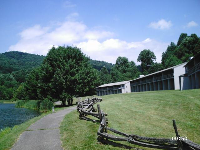
The following three photos are at the Peaks of Otter Lodge.
The photos show the lodge, the lake behind the lodge, and
one of the 3 Peaks of Otter.
Marlene hiked up this peak (Sharp Top).
It was very steep at the rocky top.
She was on all fours.
The following 2 photos show the "Headforemost Mtn" lookout point.
The following 3 photos show another lookout point.
The following 2 photos show the "Apple Orchard Falls Trail" lookout point.
The following 3 photos show the "Arnold Valley" lookout point.
The following 2 photos show the "Terrapin Mtn" lookout point.
The following 4 photos show views of the James River
from the Harry Flood Byrd Memorial bridge.
The 5th photo shows an approach to the bridge.
The following 2 photos show a view of the Bluff Mountain tunnel.
The 3rd photo shows a view down the road from the tunnel, toward our car.
The 4th photo shows a sign by the car.
The sign indicates the tunnel is in the George Washington National Forest.
The following photo shows a view from the "House Mountain" lookout point.
The following photo shows a view from another lookout point.
And the 2nd photo shows the other side of the road ---
the rock wall that resulted from carving out the road.
The following 2 photos show views from the
"Buena Vista" lookout point.
The 3rd photo shows Marlene's feet
in the front window of our car.
The following 2 photos show views from the "Irish Creek Valley" lookout point.
The following 3 photos show views from the
"20 Minute Cliff" lookout point.
One of the photos shows a man on a boulder
who was enjoying the view,
with a beer and with his shoes off.
The cliff is so-named because
"20 minutes after sunlight strikes the rock face,
dusk falls on the valley below",
in June and July. It serves the folks in
the White Rock community as a timepiece.
The following 2 photos show views from
another lookout point.
The 3rd and 4th photos show views of the
highway in both directions from that lookout point.
The following 3 photos show views from
the "Rock Point Overlook" lookout point.
The 4th and 5th photos show views of the
highway in both directions from that lookout.
The following 3 photos show views from the
"Rockfish Valley Parking Overlook" lookout point.
The 4th photo shows a view of the parking lot
and highway at that lookout.
The following 6 photos show views from
a lookout point on the descent from the
Blue Ridge Parkway to Charlottesville.
This is on highway 64.
The sign, in the 5th photo, indicates that
in 1933 a sail-plane took off from this point
and landed 125 miles away in Maryland.
Here are a few photos in Charlottesville,
at the Boar's Head Inn.
The first 2 photos show the entrance to
the registration lobby of the Inn.
The 3rd photo shows a small lake in front of
the inn, with an office building on the
other side of the lake from the inn.
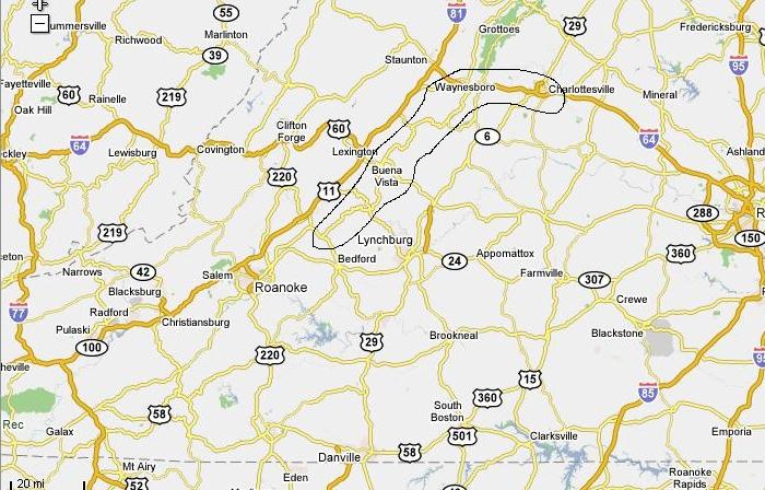
The map below shows the highway section
from which most of these Parkway photos were taken.
The photo-points section is circled by a black loop
extending from just north of Bedford to Charlottesville.

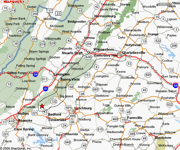
Below is an alternative map.
The star at the lower end of the loop
indicates the location of the Peaks of Otter Lodge.

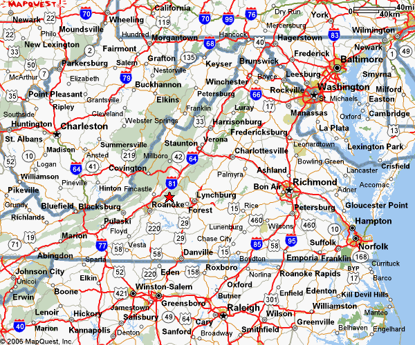
To give more perspective about the location of
the Blue Ridge Parkway and the Blue Ridge Mountains,
below is a map of all of Virginia --- and Maryland
and West Virginia and most of North Carolina.
The red star above the word "Roanoke" indicates the
location of the Peaks of Otter Lodge, and Charlottesville
is to the northeast.

|
FOR MORE PHOTOS of this area It may be a long time (years or never) before I get back to this page to add more photos, so here are some links to WEB SEARCHES for more photos of the Blue Ridge Parkway. First, you could explore the www.blueridgeparkway.org site. Then you could try WEB SEARCHES like the following.
WEB SEARCH on keywords
WEB SEARCH on keywords
WEB SEARCH on keywords Also, try the Wikipedia - 'Blue Ridge Parkway' page, and follow links from that page. Or try the Wikipedia - 'Blue Ridge Mountains' page, and follow links from that page. Or try the Wikipedia - 'Great Appalachian Valley' page, and follow links from that page. Or try the Wikipedia - 'Appalachian Mountains' page, and follow links from that page. Or try the Wikipedia - 'Shenandoah National Park' page, and follow links from that page. Or try the Wikipedia - 'Great Smoky Mountains National Park' page, and follow links from that page. |
|
Bottom of this To return to a previously visited web page location, click on the Back button of your web browser, a sufficient number of times. OR, use the History-list option of your web browser. OR ...
< Go to Top of Page, above. >Or you can scroll up to the top of this page. Page history:
Page was created 2006 Sep 05 to 10.
|