Noland Trail Photos
Newport News, VA
|
Home page >
Picture Categories menu >
This Noland Trail Photos page
|
INTRODUCTION: The photographs below are of the Noland Trail --- taken on 26 Dec 2006. The Noland Trail is a walking-running trail in Newport News, Virginia --- by the north bank of the James River. The trail goes around Lake Maury, which spills into the James River. (See map at the bottom of this page.) The Noland Trail is like an oasis of trees, water, birds, and turtles in the middle of urban sprawl. It makes a great way to get in touch with nature and take a break from life's cares. This park is reportedly the largest urban park in the U.S. east of the Mississippi River. These photographs were taken during a walk around the trail on 26 Dec 2006. The trail covers a little over 5 miles around Lake Maury. It takes about one to two hours to walk the trail. More about the trail : The Mariners Museum sits on the banks of Lake Maury. The trail passes by that museum. Here (at mariner.org) is a link to some info on the museum and the trail. The trail also crosses the Lions bridge, under which Lake Maury spills into the James River. The Lions bridge is so-named because of stone statues of Lions at each end of the bridge. People who "do" the Noland Trail ordinarily park in parking spaces either near the Lions bridge or near the Mariners Museum. The trail includes about 10 wooden bridges which span various fingers of Lake Maury. The funds for building the trail and the bridges came from the Noland family --- a family that established a plumbing supply business in Newport News. Thus the name of the trail. Newport News and the Noland Trail are near the mouth of the James River. At its mouth, the river empties into the area where the Monitor-Merrimac battle was fought in the Civil War. Just beyond that battle area is the Chesapeake Bay, then the Atlantic Ocean. Down river about two miles from the Noland Trail is the James River lift bridge and the Newport News shipyard. The shipyard is where aircraft carriers are designed and built. The lift bridge typically opens a couple of times a day, to allow tall ships and barges to travel up/down-river, toward/from Richmond. |
|
How the photos are presented : Each photo is shown scaled to a width proportional to the width of your browser window. Hence, you can change the size of the photos by changing the width of your browser window. (On a 'smartphone', you can do this by changing the orientation of the phone from 'portrait' mode to 'landscape' mode.) Each photo is a link to a new window (or tab) that shows the image at its natural size. Click on any photo to see it in a separate window. Close (or minimize) the separate window(s) to access this window again. If you hold the mouse cursor over a photo, a small pop-up 'balloon' will provide a brief description of the photo, with the date-taken. (These pop-ups should work in most web browsers.) Most of the photos are medium- to high-resolution --- more than 600 pixels wide. |

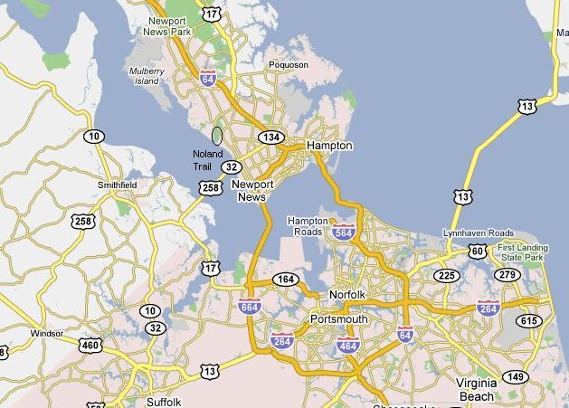
This map shows the area in which these trail photos were taken.
The area is circled by a small black ellipse --- just above the
label "Noland Trail" on the map.
The battle of the Monitor and the Merrimac was fought
in the area just south of the "Newport News" and "Hampton" labels.
To the right of the "Hampton" label is the Chesapeake Bay.
And to the right of that (out of the picture) is the Atlantic Ocean.
|
FOR MORE PHOTOS of this area It may be a long time (years or never) before I get back to this page to add more photos, so here are some links to WEB SEARCHES for more photos of the Noland Trail.
WEB SEARCH on keywords
WEB SEARCH on keywords
WEB SEARCH on keywords Also, try the Wikipedia - 'Mariners Museum and Park' page, and follow links from that page. Or try the Wikipedia - 'Newport News, Virginia' page, and follow links from that page. Also, try the Wikipedia - 'James River' page, and follow links from that page. Or try the Wikipedia - 'Hampton Roads' page, and follow links from that page. Or try the Wikipedia - 'Battle of Hampton Roads' page, and follow links from that page. Or try the Wikipedia - 'Chesapeake Bay' page, and follow links from that page. |
|
Bottom of this To return to a previously visited web page location, click on the Back button of your web browser, a sufficient number of times. OR, use the History-list option of your web browser. OR ...
< Go to Top of Page, above. >OR you can scroll up to the top of this page. Page history:
Page was created 2007 Mar 14.
|